While Yosemite Valley gets all the attention, it’s the much more expansive High Sierra section of the park that keeps me coming back. For this trip - which I estimate to be my tenth time at Yosemite - we planned a mostly cross-country route in the slightly less-visited eastern section.
Our 4 day/3 night itinerary had us starting at Mono/Parker trailhead on the Mono Pass trail, continuing south over Parker Pass to Parker and Koip Peaks, backtracking and heading over Kuna Pass to Lyell Canyon, climbing Lyell Peak from its headwaters, and then an easy stroll back along Lyell Creek to Tuolumne.
I avoided driving this time by flying up to Reno, where Ben picked me up and we eventually made it down the eastern Yosemite entrance. At Tuolumne Meadows, we met up with our other hiking partners, Arlen and Sarah, and immediately became jealous of their cool tarp tent and various pieces of ultralight gear (including solar panels for charging battery-powered devices). Unfortunately I’m too lazy to actually get cool new gear myself.
Day 1: The ghost cabin
Mono/Parker Trailhead > below Parker Pass

Yes, it was sunny at the trailhead.
Permit in hand, we piled into Arlen and Sarah’s jeep and drove the short distance to the trailhead, and we were hiking by 3:30pm. Usually, the first few trail miles of a trip are uneventful, but we got lucky this time - first when we stumbled on a choice bunch of mushrooms (Sarah is a forager), and then when we saw a bear 100 yards away through the trees! It definitely noticed us, but didn’t seem that interested, continuing on south parallel to the trail before heading out of sight. It turns out that bear sightings all have to be reported, a task that fell to me after the hike was over (I love to follow the rules). Strangely, despite spending so much time in the backcountry, this was only my second bear sighting in the wild.

Gaia says it’s haunted.
After about 2 1/2 miles the trail left Parker Pass creek and began its ascent to Parker Pass. The pass itself was not particularly dramatic, or even easy to spot - it was more like an imperceptible stroll over a hill separating two broad canyons. Somewhere below the pass - I’m not sure exactly where, it was hard to tell - we stumbled upon the remnants of an old miner’s cabin (a ‘ghost cabin’ and various rusted pieces of equipment. It constantly surprises me how much mining detritus still litters the High Sierra, more than a hundred years since the mines fell out of use. Those old timers would have encountered some pretty harsh conditions up here trying to pull silver deep out of the granite.
Up the switchbacks.
At some point, we began descending from Parker Pass, and within half a mile arrived at a string of small lakes surrounded by ample campsites hidden in the rocks. Ben and I set up our own tents while (once again) admiring Arlen and Sarah’s <2 lb. two-person tarp tent. Lucky for us, our companions were also much more adept at (and willing to spend time) cooking a more elaborate backcountry meal. Tonight, it was cheesy beans with Fritos. Felt very satisfied as I took in the multicolored sunset reflecting off the lakes.
Day 2: Peak goofs
Below Parker Pass > below Kuna Crest Saddle
Koip Peak (12,972′, Class 1), Kuna Peak (12,986′, Class 2), Parker Peak (12,858′, Class 1)
July and August in the Sierra are truly fantastic. Great weather (with only the occasional thunderstorm), beautiful wildflowers, and the big one - no mosquitos. Still, my favorite High Sierra months have been steadily encroached upon - at at times, ruined - by the rising incidence of wildfires in the densely vegetated forests below. Our hiking party was aware of one such fire burning in the northwest section of Yosemite that began a day or two before we started, and woke up on Day 2 to a small plume of smoke on the horizon. Consider this a preview of what was to come later.
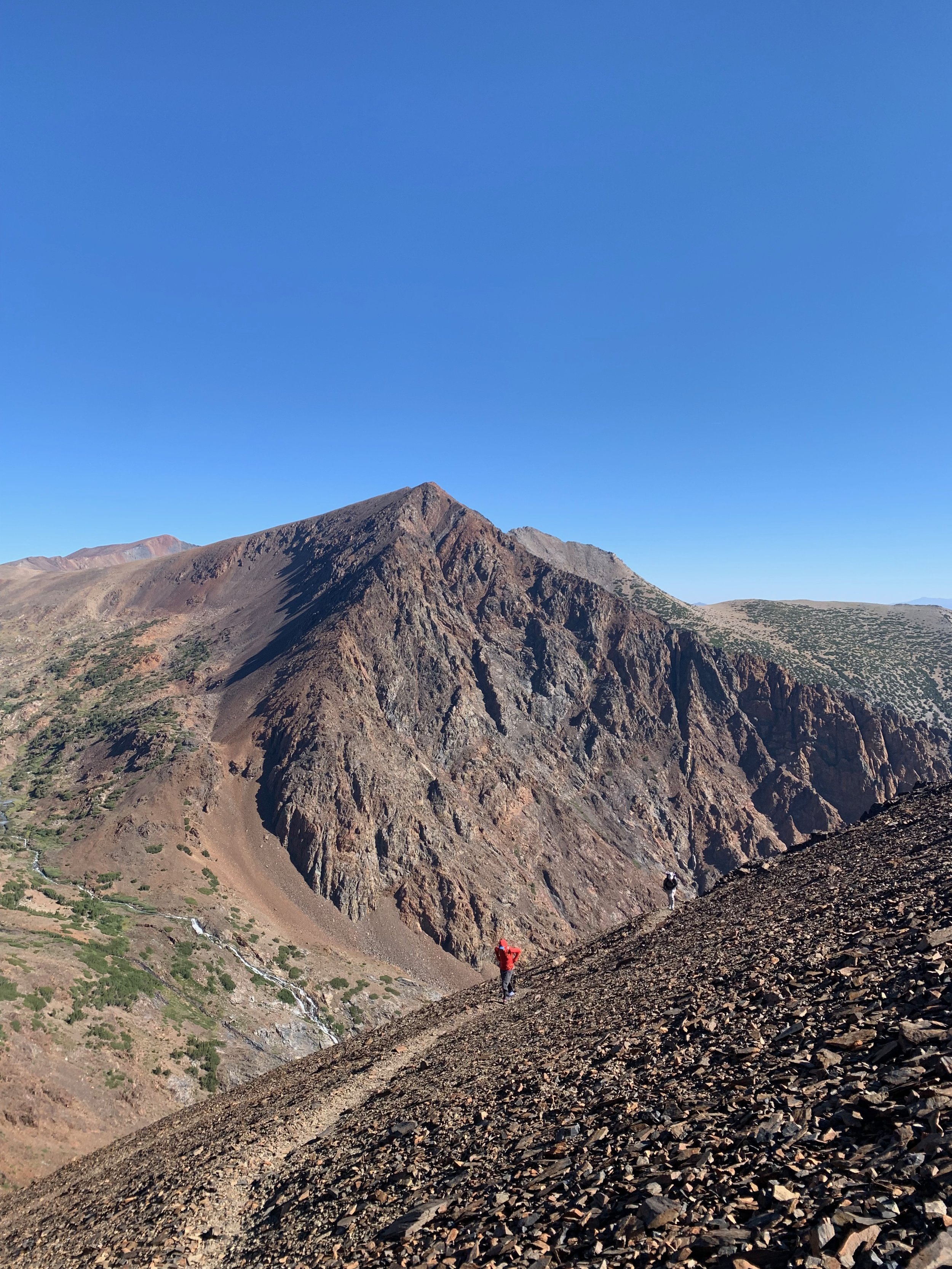
But for the time being we had three nearly 13k ft peaks and a high pass on the day’s agenda - though these two sets of goals were in different directions from our camp. We first struck out for the peaks, leaving most of our gear and large packs behind and hitting the trail with a bit of water and lunch just after 8am. Following the trail southeast, we gently descended to a drainage before beginning a rigorous ascent via 20+ long switchbacks up the north slopes of the Kuna-Koip-Parker ridge. Being late in the season, we encountered no snow and made good time to the pass itself. The wind just about blew our socks off.
Heading first to Koip Peak to the west, we followed a clear use-trail along the ridge with a few small drops and ascents, finding ourselves at the summit after about 20 minutes. The peak held great views of the Parker valley to the north and Alger Lakes to the south, as well as the slightly higher Kuna Peak (and below it and us, Kuna Glacier) less than half a mile to the west - our next destination. The use-trail mostly disappeared in a tangle of talus, but some light Class 2 ridge climbing (actually just below the ridge to the north) led us to Kuna after another ~25 minutes. Views from the peak were similarly grand, with the bonus of a clearer line of sight down into Lyell Canyon and, at the canyon’s head, Mount Lyell. This was to be our final peak of the trip and looked imposing with its large glacier.
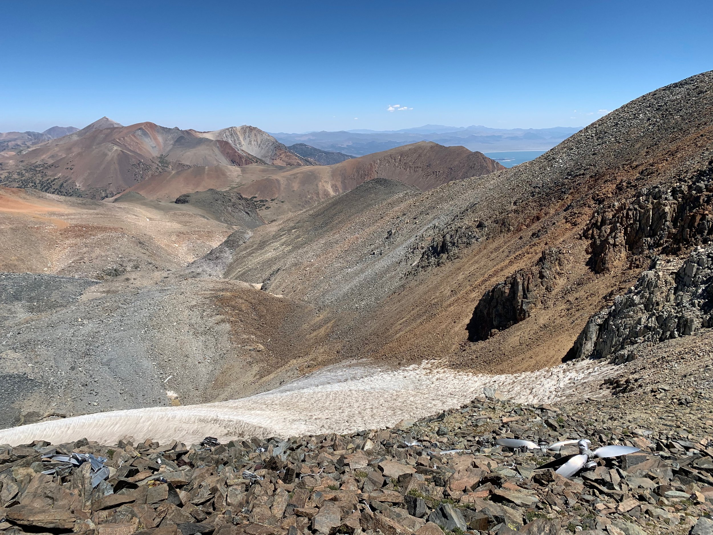
Propeller above Kuna Glacier.
Scrambling back just below the ridge, we caught a small glint of shiny metal below us on the slopes just above Kuna Glacier. Of course we had to take a look. The slope was comprised of relatively stable talus blocks, easily navigated, and starting about 50 ft below the ridge we began encountering pieces of wreckage from what appeared to be a plane. At a small, flatter break in the slope ~100 ft down, we came across even more, including a very rusty propeller and pieces of fuselage. Arlen, being an engineer and industrial designer, was able to identify the uses of a surprising number of twisted metal pieces - and made a fairly accurate assumption that the plane was from the 1940s or 50s. [Later, we would read that the crash occurred in 1943 when an air force plane crashed into Koip Peak - write up and photos here.]
From the crash site, we ascended back to the ridge traverse and met the use-trail once again at Koip. Ben and I decided to brave the wind (which had picked up again) to tag Parker Peak and complete the three-peak challenge. On a calm day, Parker is an easy Class 1 walk-up, but we had to really put our heads down and lean into the gusts to get ourselves from the pass to the summit. Once on top, we sheltered among a makeshift wall of small talus blocks (apparently we weren’t the only ones to encounter wind), before calling it quits and heading north down the slope to meet the switchbacks back down.

Ben emerging onto the upper slopes of Mount Lyell.
After all this, we still had a good hike and high cross-country pass ahead of us. We gobbled our lunch at the bottom of the switchbacks, hiked back uphill to our packs below Parker Pass, and up and over the pass once again. After a mile or so, we left the trail to contour west above Spillway Lake until we met the outflow from Helen Lake, above us to the southwest. We climbed up an easy grassy hillside to the shores of Helen Lake, then circled around its relatively flat north and west shores to the south shore and the beginning of a big, talus-y ascent to Kuna Crest Saddle. The Saddle is rated Class 2, but luckily not too steep and loose, with ample solid rock and some grassy sections making for a relatively enjoyable climb. Still, we were pretty pooped by the time we got to the top, and began immediately looking for a campsite as we traversed south and east below an adjacent cirque with a lake and outlet. Before too long we found suitable sites near the creek in beautiful timberline country, providing excellent views of Lyell Canyon below. From this vantage point, we could also see the ominous plume of smoke to the northwest continuing to belch.
Day 3: It’s Lyell Time
Below Kuna Crest Saddle > below Mount Lyell
Mount Lyell (13,100′, Class 2-3)
Mount Lyell is an iconic summit and the highest point in Yosemite National Park. Ben hiked it a couple of years earlier in a heavy snow year, and recounted a sketchy Class 4 bergschrund he had to negotiate between the glacier and the upper mountain. Class 4 is a little beyond my pay grade so I was admittedly a bit nervous about the ascent, but figured it was worth a shot.

Sarah choosing glacier over talus.
Our minds were elsewhere, however - the plume of smoke had gotten bigger and was making for increasingly hazy views. Over breakfast we expressed the hope that the smoke would stay low and to the north, but it was anybody’s guess which way the winds would blow. It stayed like this most of the morning as we contoured west below Mount Andrea Lawrence and Donahue Peak, eventually meeting the PCT/JMT below Donahue Pass. Ben knew of a good campsite off-trail a half mile or so to the north, and we arrived at a lovely little lake in time for lunch and an afternoon Lyell ascent.

A little product placement for my friends at MSR.
Lyell turned out to be one of the more enjoyable climbs in recent memory. It has several sections. First, from the lake, one climbs up grassy ramps and angled granite benches with plenty of wildflowers still in bloom. You then reach the glacier moraine, climbing alternating solid and loose-ish talus between Lyell and Maclure glaciers to the col between the peaks. Once at this saddle, it’s fun Class 3 climbing on solid granite, with a couple puzzling route-finding sections and enough light exposure to make it challenging and exhilarating. Eventually, you pop up onto a gently angled talus slope that leads directly to the summit. No sketchy sections and no negotiating glacier crevasses - just a classic Sierra mountaineering summit.
We made good time on the descent, this time using some lingering snow to hop down past some of the looser talus. I was feeling good - despite the increasing smoky haze - and half hiked/half jogged from the moraine back to camp. The smoke just kept getting worse as the rest of the party arrived and we cooked dinner. We were pretty sure we’d be walking in a choking haze the next day all the way from the upper canyon to Tuolumne. That’s what you get these days when you plan a hike in August.
Day 4: Call me Tuolumne
I slept pretty well, but was reluctant to open the fly flap and be enveloped in gray smoke. Incredibly, though, that’s not what happened at all - the smoke had in fact cleared during the night! We’re such lucky bastards. I’m pretty sure we were all whistling as we cooked breakfast and packed up camp.
With no smoke and sunny skies, the ~10 trail miles back to Tuolumne Meadows were a cakewalk. We stopped for a snack at some point, but made it to the Lyell Fork bridge 1.5 or so miles from the backcountry office before having lunch. We of course had to jump in for a swim (it was hot without that smoke scattering the sun’s rays). A great lunch spot topped off with a big mushroom score by Sarah. Don’t ask me what kind of mushroom it was (it was gray and dirty).

Cruisin’ on back.
Putting the boots back on for just 1.5 miles was a bit annoying but we made quick work of it and arrived at Ben’s car in early afternoon. Ben’s car couldn’t easily fit all four of us, so I said goodbye to Arlen and Sarah as Ben shuttled them back to their jeep at Mono/Parker trailhead. I used the half hour of so to tell the ranger my brave tale of the Day 1 bear sighting - she was suitably impressed I’m sure. Ben picked me back up and we headed west towards the Central Valley, into the smoke that had behaved so well in the high country. We stopped in almond tree-rich Ripon for a big ole burrito and were in Oakland late evening.